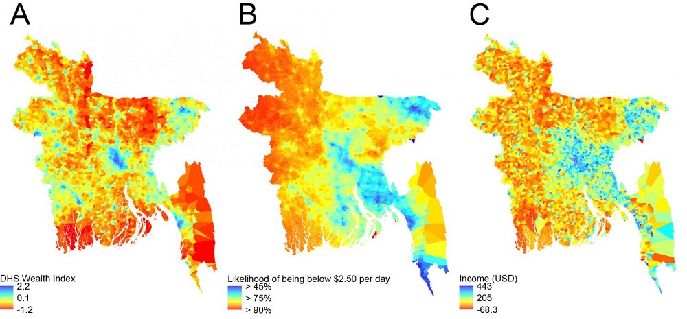
An international team has, for the first time, developed a way of combining anonymised data from mobile phones and satellite imagery data to create high resolution maps to measure poverty.
The researchers, led by WorldPop at the University of Southampton and the Flowminder Foundation, have worked with Telenor Research and mobile phone company Grameenphone to examine rates of poverty and its distribution across Bangladesh -- analysing a range of information relating to mobile phone usage. Findings from the study, funded by the Bill and Melinda Gates Foundation, are published in the Journal of the Royal Society Interface.
The team found that by combining mobile data and geospatial data from satellites, they were able to produce poverty predictions which are comparable with those made from traditional sources, but with significant advantages.
Lead author Dr Jessica Steele explains: "Census and household surveys are normally used as data sources to estimate rates of poverty. However, they aren't regularly updated -- for example, censuses only take place every ten years - and in low income countries, surveys can be patchy.
"The advantage of using mobile phone data is that it provides us with information which is continually updated, can be interrogated in a variety of ways and can track changes on an ongoing basis. Paired with satellite data that has similar features, it can give a much more dynamic view of poverty and its geographic spread."
Every time a person uses a mobile it sends information to a receiving tower and gives an approximate location of where they are. It also contains information about levels of data usage, numbers of texts sent, times calls were made and their duration. It can reveal how much and how far people are travelling, as well as the type of phone they're using -- i.e. basic mobile device, or smart phone.
This kind of anonymised data helps build a picture of poverty. For example, monthly credit consumption on mobiles, and the proportion of people in an area using them, can indicate household access to financial resources -- while movements of mobiles and their use of networks provide information on individuals' economic opportunities.
Similarly, remote sensing from satellites can indicate the living conditions of communities. Researchers in WorldPop have, for several years, undertaken research on how data on rainfall, temperature and vegetation reveals information about agricultural productivity, while how far people live from roads and cities and whether they can light their homes may reflect a community's access to markets and information.
Dr Steele adds: "Satellite data can provide us with excellent information about living conditions in rural areas, but in tightly packed cities it's more difficult. It's the reverse for mobiles - more masts in cities means more information, contrasted with the countryside where mobile receiving towers can be thinly spread."
The researchers recognise that some of the very poorest in society may not own a mobile, but even taking this in to account, they were able to identify distinct differences between low income informal settlements and richer areas.
In 2016, the United Nations pledged to '...end poverty in all forms and dimensions by 2030' as part of its Sustainable Development Goals. One of the steps towards achieving this involves targeting the most vulnerable in society. The researchers are now expanding their work to other countries. They hope their findings can be utilised to track poverty more effectively in the future and provide detailed and accurate information to better inform governments and relief organisations.
